True goose identification in the St. Lawrence goes beyond species—it’s about understanding the ecosystem, using gear effectively, and observing ethically.
- Success depends on recognizing specific behaviors linked to key habitats like the tidal mudflats of Cap Tourmente.
- Choosing the right binoculars (e.g., 8×42 for wider field of view) is critical for spotting subtle differences in fast-moving flocks.
Recommendation: Shift your mindset from a passive observer to an active, informed participant who contributes valuable data to conservation science through ethical practices.
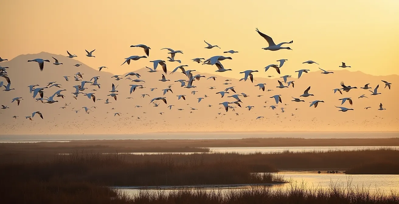
The sight of thousands of geese descending upon the St. Lawrence Estuary is an unforgettable natural spectacle. The air fills with a cacophony of calls, and the sky can seem to move as vast flocks wheel and turn in unison. For any nature enthusiast, the challenge and thrill lie in making sense of this beautiful chaos. It’s one thing to say “that’s a Snow Goose” or “that’s a Canada Goose,” but it’s another thing entirely to truly understand what you are seeing.
Many guides offer simple visual keys, but they often miss the most crucial element: context. Identifying migratory geese isn’t just a visual puzzle; it’s an ecological one. The key to moving from a casual spotter to a knowledgeable birder lies in understanding the dynamic interplay between the birds, their behavior, the specific habitats of the St. Lawrence, and even the gear you carry. This goes beyond simple identification and touches upon responsible observation and our role in conservation.
But if the secret isn’t just in the field guides, where is it? It’s in learning to read the landscape, understanding the pressures the birds face, and recognizing that every observation can be a piece of a larger scientific puzzle. It’s about becoming a citizen scientist.
This guide is designed to take you on that journey. We will explore not only how to tell the species apart, but why their behaviors change, how to choose the right tools for the job, where the best observation spots are, and how your actions—from the car you drive to how you log a sighting—can have a real impact on the birds you’ve come to admire.
To help you navigate these crucial aspects of birding in one of Canada’s most vital migratory flyways, this article breaks down the essential knowledge you need. The following sections will guide you from understanding bird behavior to becoming a more effective and ethical observer.
Summary: A Birder’s Complete Guide to the St. Lawrence Flyway
- Why Do Canada Geese Change Their Flight Paths in Late November?
- 8×42 vs. 10×42 Binoculars: Which Is Better for Tracking Fast-Moving Waterfowl?
- The Baiting Mistake That Harms Migratory Birds and Ruins Your Photos
- Cap Tourmente vs. Point Pelee: Which Site Offers the Best Waterfowl Density?
- How to Log Your Sightings on eBird to Help Conservation Science?
- Leave No Trace: How to Camp on Coastal Moss Without Destroying the Ecosystem?
- Electric Car vs. Keeping Your Old Gas Car: Which Is Truly Greener?
- Exploring Newfoundland’s Rugged Coast: The 5 Safety Rules for Solo Hikers
Why Do Canada Geese Change Their Flight Paths in Late November?
Observing a sudden shift in the flight patterns of Canada Geese in late autumn isn’t witnessing random movement; it’s seeing a direct response to environmental pressures. The St. Lawrence corridor is not just a flyway but a critical staging area—a giant service station where birds rest and refuel before the next leg of their arduous journey south. This stopover is essential for building the energy reserves needed for a successful migration.
The behavior of Greater Snow Geese provides a perfect model for understanding this process. Data on their habits in the St. Lawrence shows that around 80% of the entire population will stop over, staying for an average of 19 days. During this time, they voraciously consume the rhizomes of American Bulrush in the tidal marshes. This intense feeding by hundreds of thousands of birds inevitably leads to resource depletion. By late November, the most accessible and energy-rich food sources in their initial staging locations are often exhausted.
This depletion is the primary trigger for changing flight paths. The geese aren’t getting lost; they are making a calculated decision to move. They might shift to nearby agricultural fields to feed on leftover grain or move to different sections of the river where food is more plentiful. For the observer, this means that a hotspot in October might be quiet by late November. Understanding this principle of resource depletion allows you to predict where the birds might move next and appreciate their incredible survival instincts.
8×42 vs. 10×42 Binoculars: Which Is Better for Tracking Fast-Moving Waterfowl?
Choosing binoculars can feel overwhelming, but for tracking fast-moving waterfowl in the vast landscapes of the St. Lawrence, the decision often comes down to a trade-off between magnification and field of view. While 10x magnification offers a closer look, the wider field of view (FOV) of 8x binoculars is often the superior choice for the dynamic conditions of goose observation.
When a massive flock takes flight, or you’re trying to pick a single Cackling Goose out of a sea of Canada Geese, a wider FOV is your best ally. It makes it significantly easier to locate the flock in your lenses and track their movement without losing them. Furthermore, 8x binoculars typically offer a larger exit pupil, which translates to a brighter image in the low-light conditions of dawn and dusk when birds are most active. They also show less handshake, making for a more stable, pleasant viewing experience over long periods.
Field Test: The Baie-du-Febvre Challenge
A practical scenario illustrates this perfectly. During the “Baie-du-Febvre Challenge,” birders attempt to spot the smaller, shorter-billed Cackling Goose within fast-moving flocks of Canada Geese. As field tests confirm, in conditions where birds are close or moving quickly, the 8x binoculars consistently outperform 10x models. The wider field of view provides more background context, making it easier to acquire and lock onto a target within a swirling flock. The 10x magnification may get you “closer,” but only if you can find the bird in the first place.
This table breaks down the key differences for birding in waterfowl-rich environments.
| Feature | 8×42 | 10×42 |
|---|---|---|
| Field of View | ~400 feet at 1000 yards | ~330 feet at 1000 yards |
| Exit Pupil | 5.25mm (better low light) | 4.2mm |
| Image Stability | More stable handheld | More shake visible |
| Best Use | Fast-moving flocks, dense habitats | Distant stationary birds, open water |
| Minimum Focus Distance | ~8 feet | ~10-25 feet |
The Baiting Mistake That Harms Migratory Birds and Ruins Your Photos
The desire to get that perfect, frame-filling photograph of a goose is understandable. In an attempt to draw birds closer, some people resort to baiting—tossing out corn, bread, or other food. While it may seem harmless, this practice is not only often illegal but is profoundly damaging to both the birds and the scientific understanding of their behavior. It creates a deceptive and harmful illusion of nature.
Baiting habituates birds to humans and can lead to the spread of disease in unnaturally dense congregations. It also provides poor nutrition compared to their natural diet, which is especially dangerous during the critical migration period when they need specific nutrients. Beyond the direct harm to the birds, baiting has a more insidious effect on conservation efforts. It creates artificial hotspots, concentrating birds in areas they wouldn’t normally use. When observers log these sightings on platforms like eBird, they are inadvertently submitting corrupted data.
This misleading information can skew scientific analyses of habitat use, population distribution, and migratory timing, ultimately leading to flawed conservation strategies. As one analysis based on conservation research states:
Baiting corrupts scientific data, creating artificial hotspots that skew citizen science results on eBird and misinform conservation strategies.
– Analysis based on conservation research, Understanding Waterfowl Management Principles
Truly great wildlife photography captures natural behavior, not staged performances. The satisfaction comes from using fieldcraft, patience, and knowledge of the birds’ habits to get your shot ethically.
Your 5-Point Checklist for Ethical Waterfowl Photography
- Review Regulations: Before any outing, check Canada’s Migratory Birds Regulations to understand the strict laws against baiting and a “baited area.” Ignorance is no excuse.
- Assess Your Distance: Inventory all your interactions. Are you consistently maintaining a minimum 50-meter distance from feeding or roosting flocks to prevent disturbance? Use your lens’s focal length, not bait, to get closer.
- Audit Your Gear: Check your camera bag. Have you removed any potential bait? Never carry bread, corn, or other human food with the intention of feeding wildlife in parks or natural areas.
- Focus on Natural Scenes: When scouting locations, prioritize areas where birds are feeding naturally. Confront your motives: is your goal to document authentic behavior or to create an artificial scene?
- Plan to Report: If you witness illegal baiting, have the contact information for your provincial wildlife authority or Environment and Climate Change Canada’s wildlife enforcement line ready. Reporting helps protect the birds and the integrity of the habitat.
–
Cap Tourmente vs. Point Pelee: Which Site Offers the Best Waterfowl Density?
For Canadian birders, Cap Tourmente National Wildlife Area in Quebec and Point Pelee National Park in Ontario are legendary sites. Both offer world-class birdwatching, but for waterfowl, they provide vastly different experiences. The choice between them depends entirely on your goal: are you seeking the overwhelming spectacle of a single species, or the diverse richness of many?
Cap Tourmente is the undisputed champion of the Greater Snow Goose. Situated at a narrowing of the St. Lawrence River, its vast tidal mudflats and bulrush marshes are the primary staging area for nearly the entire global population. During the peak in early to mid-October, the sheer density is breathtaking, with hundreds of thousands of birds creating a “river of white.” The viewing experience is one of immense scale, often from open, expansive platforms overlooking the marsh.
Point Pelee, on the other hand, is a master of diversity. As a peninsula jutting into Lake Erie, it acts as a migrant trap for a huge variety of birds, including a wide array of waterfowl. While you won’t see the single-species density of Cap Tourmente, you have a much higher chance of spotting numerous species of ducks, swans, and other geese during their respective migration windows. The viewing style is often more intimate, using hides tucked into the freshwater marshes.
The best site is therefore subjective. For the raw power and density of the Snow Goose migration, nothing on the continent compares to Cap Tourmente. For a checklist filled with diverse waterfowl species, Point Pelee is a premier destination.
| Feature | Cap Tourmente | Point Pelee |
|---|---|---|
| Peak Species | Snow Geese (80% of population) | Diverse waterfowl (ducks, swans) |
| Peak Timing | October 5-20 | Variable by species |
| Habitat Type | Tidal mudflats, bulrush marshes | Freshwater marshes, lake shoreline |
| Viewing Style | Expansive open platforms | Intimate marsh hides |
| Special Food Source | Scirpus americanus (bulrush) | Mixed aquatic vegetation |
How to Log Your Sightings on eBird to Help Conservation Science?
Logging your bird sightings on a platform like eBird, managed by the Cornell Lab of Ornithology, can feel like a simple personal record-keeping tool. However, it is so much more. Every complete, accurate checklist you submit becomes a vital data point that helps scientists understand the health, distribution, and behavior of bird populations. You are not just a birdwatcher; you are a sensor in a massive global monitoring network.
To ensure your data has maximum scientific value, it’s not enough to just list the species. The key is to follow a consistent protocol. A “complete checklist” is one where you report every species you were able to identify, for a specific duration of time, over a specific distance or at a single location. Reporting effort (time and distance) is what allows scientists to calculate abundance and trends. Also, be precise with your location—don’t just plot a point for “Cap Tourmente,” but for the specific trail or lookout you were on.
Adding notes on behavior (e.g., “feeding on bulrush,” “in flight heading south”) and correctly counting or estimating flock sizes adds layers of valuable information. This is how you move from a casual lister to a true citizen scientist, providing the raw data that powers real-world conservation.
Case Study: The Atlas of the Breeding Birds of Southern Quebec
The importance of this data is not theoretical. Major conservation projects depend on it. For instance, the second Atlas of the Breeding Birds of Southern Quebec relies heavily on eBird data submitted by volunteers. These observations help track changes in breeding ranges, identify population declines, and inform habitat protection priorities along the St. Lawrence corridor. Similarly, platforms like the Ducks Unlimited Canada Migration Tracker use citizen sightings to follow the progress of migration in near real-time, providing insights that were impossible just a few decades ago. Your checklist matters.
Leave No Trace: How to Camp on Coastal Moss Without Destroying the Ecosystem?
The rugged, beautiful coastlines of Eastern Canada, from the St. Lawrence to Newfoundland, are often carpeted with thick beds of moss and lichen. When searching for a place to pitch a tent or even just to sit and watch for birds, these soft carpets can seem inviting. However, the answer to the question “how do you camp on coastal moss?” is simple: you don’t. These ecosystems are exceptionally fragile and a cornerstone of the coastal environment.
Moss and lichen beds on the rocky shores of the Canadian Shield can take decades, or even centuries, to grow. A single footstep can crush them, and the passage of a tent being set up can leave a scar that persists for years. They are crucial for retaining moisture, preventing erosion, and providing a micro-habitat for countless tiny organisms. The “Leave No Trace” principle of traveling and camping on durable surfaces is paramount here. Always choose bare rock, sand, or gravel for your campsite and pathways. Stay on established trails whenever they exist.
This principle extends beyond just where you step. It’s a holistic approach to minimizing your impact. This includes packing out everything you pack in, observing wildlife from a distance to avoid causing stress, and being mindful of things like light pollution. A bright headlamp shone across a shoreline at night can disorient roosting birds, forcing them into flight and wasting precious energy reserves. Using a red filter and keeping your light pointed down is a simple, effective way to reduce your impact.
Electric Car vs. Keeping Your Old Gas Car: Which Is Truly Greener?
For the conservation-minded birder, the environmental impact of getting to the birding spot is a valid concern. The debate between driving a new Electric Vehicle (EV) or sticking with an older, paid-off gasoline car is complex, but in the specific context of birding in Quebec, the EV holds a significant advantage. This is almost entirely due to the province’s power source: hydroelectricity.
While manufacturing an EV has a higher carbon footprint than an internal combustion engine (ICE) vehicle due to battery production, this “carbon debt” is quickly paid off in Quebec. Charging an EV from a grid powered almost entirely by clean hydro means the operational emissions are near zero. An older gas car, no matter how well-maintained, will continue to produce CO2 and other pollutants with every kilometer driven.
Furthermore, EVs offer a unique practical benefit for birdwatching: a silent approach. The lack of engine noise can reduce stress on wildlife and allow you to get closer to sensitive areas like wetlands without causing a disturbance. This is a tangible advantage in places like Îles de la Paix National Wildlife Area. While rural charging access can still be a challenge on remote routes like the Côte-Nord, the infrastructure is rapidly expanding along major corridors.
Birder’s Carbon Footprint Analysis for Quebec Routes
Analysis of typical birding trips from Montreal to premier sites like Cap Tourmente starkly illustrates the EV’s benefit. For a dedicated birder who might travel thousands of kilometers a year tracking migrations, the lifecycle emissions of an EV in Quebec are significantly lower. The quiet operation is not just a bonus; it’s a tool that enhances the ethical observation of wildlife in their natural habitat, aligning perfectly with the core values of a passionate birder.
| Factor | Electric Vehicle | Older Gas Vehicle |
|---|---|---|
| Montreal-Cap Tourmente emissions | Near zero (hydro grid) | ~40kg CO2 |
| Wildlife disturbance | Silent approach | Engine noise stress |
| Rural charging access | Limited along Côte-Nord | Gas stations available |
| 10-year lifecycle (20,000km/year birding) | Lower total emissions in Quebec | Higher operational emissions |
Key Takeaways
- True goose identification requires understanding ecological context (like staging areas) and not just visual field marks.
- For fast-moving waterfowl, 8×42 binoculars are often superior to 10×42 due to a wider field of view and better low-light performance.
- Ethical observation is paramount: never bait birds, as it harms them and corrupts vital citizen science data used for conservation.
Exploring Newfoundland’s Rugged Coast: The 5 Safety Rules for Solo Hikers
Whether you’re exploring the dramatic, rocky headlands of Newfoundland or the tidal flats of the St. Lawrence, personal safety is the foundation of any successful and responsible birding trip. The very wildness that makes these places so attractive also presents real risks. For the solo enthusiast, being prepared is not optional; it’s a requirement. This means moving beyond just packing binoculars and a field guide to adopting a robust safety protocol.
Situational awareness is your most important tool. This includes being aware of other people, especially during hunting season. Wearing bright, non-natural colors (like blaze orange) is a crucial precaution in areas where waterfowl hunting is permitted. It also means being aware of wildlife beyond the birds. In many coastal areas, access trails pass through forests where black bears are present, making bear spray a wise addition to your pack.
The most unique and often underestimated danger in coastal birding is the environment itself. The weather along the Atlantic coast and St. Lawrence River can change in an instant, with sudden, dense fog rolling in and reducing visibility to near zero. Most critically, the tides in estuaries can be extreme. The St. Lawrence Estuary, for example, can experience tidal ranges of up to 6 meters. An accessible mudflat at low tide can become a dangerous trap of deep water in a surprisingly short time. Always carry and consult a tide chart before venturing onto any shoreline.
By integrating these principles—from gear selection and ethical conduct to personal safety—you transform your hobby. You become a more effective, respectful, and knowledgeable birder, ready to fully appreciate the wonders of the St. Lawrence corridor and contribute to its preservation.
Frequently Asked Questions about Identifying Migratory Geese Species in the St. Lawrence Corridor
What is the minimum safe distance from roosting geese?
Maintain at least 50 meters from roosting flocks to avoid causing energy-wasting flight responses, especially critical during migration periods.
How can light pollution affect shoreline birds?
Headlamps and flashlights can disorient roosting waterfowl and disrupt their circadian rhythms. Use red filters and keep lights pointed downward.
Which coastal surfaces are most vulnerable?
Moss and lichen beds on rocky shores take decades to recover from trampling. Stay on bare rock or established trails whenever possible.