Successfully capturing epic Atlantic swells is not about luck; it’s a professional discipline built on three pillars: prediction, technique, and preservation.
- Location mastery involves reading underwater topography to predict where massive waves will form, not just reacting to them.
- Creative control means choosing between fast shutters for explosive detail and long exposures for ethereal movement, or even blending both.
- Gear longevity is ensured by a non-negotiable, three-stage decontamination protocol that removes corrosive salt after every shoot.
Recommendation: Treat gear safety as an integral part of your creative process, not an afterthought. Your camera’s survival depends on it.
The raw power of a North Atlantic storm battering the coastline is a siren’s call for any landscape photographer. The churning sea, the explosive spray, the dramatic light—it’s a scene that promises unforgettable images. Many photographers, drawn by this spectacle, arrive with high hopes, armed with what they believe is common sense: watch the tides, use a sturdy tripod, and maybe cover the camera with a plastic bag. They often leave with disappointing photos and, far worse, gear that has been silently and fatally compromised.
The fundamental misunderstanding is that storm photography is simply about being there. The reality, especially on the volatile coasts of Ireland and Atlantic Canada, is that it’s a craft of anticipation and meticulous process. The real work happens before you even press the shutter and continues long after you’ve packed up. The difference between an amateur who ruins a lens in one season and a professional who builds a career on these images lies in a deeper understanding of the environment and a rigorous workflow.
But what if the key to both safety and spectacular shots wasn’t found in a weather app, but on a marine chart? What if the secret to protecting your thousand-dollar lens wasn’t a fancy rain cover, but a simple bottle of distilled water and a specific, three-stage cleaning ritual? This guide moves beyond the platitudes to deliver the professional’s methodology. We will explore how to read the sea to predict its most dramatic moments, master the technical skills to capture its power, and implement the essential protocols to ensure you and your gear are ready for the next storm.
This article breaks down the essential knowledge required to master this demanding genre. We will delve into the science behind wave formation, the creative decisions behind the shot, and the critical safety and maintenance procedures that define professional practice on these rugged coastlines.
Summary: A Professional’s Guide to Capturing Stormy Ocean Swells
- Why Do “Rogue Waves” Occur More Frequently at Specific Headlands?
- Long Exposure vs. Fast Shutter: Which Technique Captures the Power of the Swell Best?
- The Salt Corrosion Mistake That Ruins Lenses in One Season
- Peggy’s Cove vs. Tofino: Which Coast Offers Safer Vantage Points for Storm Watching?
- RAW Processing: How to Bring Out the Detail in White Foam Without Blowing Out Highlights?
- Why Does the Weather in Newfoundland Change Faster Than in the Rockies?
- How to Read Glacial Ice Calving Signs Before It’s Too Late?
- Exploring Newfoundland’s Rugged Coast: The 5 Safety Rules for Solo Hikers
Why Do “Rogue Waves” Occur More Frequently at Specific Headlands?
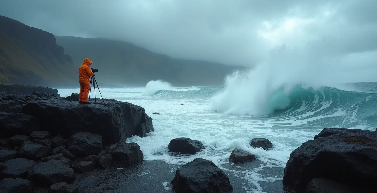
The term “rogue wave” often conjures images of random, unpredictable monsters rising from the deep. For the professional coastal photographer, however, the most dangerous waves are anything but random. They are the predictable result of swell topography—the interaction between incoming ocean energy and the unseen underwater landscape. Certain headlands and coastlines act as natural lenses, focusing wave energy into concentrated, explosive bursts that can appear unexpectedly large compared to the surrounding sea state.
This phenomenon is driven by bathymetry. Submarine canyons, shallow reefs, and the specific shape of a headland can refract and converge swells from multiple directions. When the crests of these waves align, a process known as constructive interference occurs, creating a wave significantly larger and more powerful than any single swell. As a photographer, understanding this means you can predict *where* the action will happen, allowing you to set up in a safe, elevated position with a telephoto lens and wait for the show.
Case Study: Dingle Peninsula’s Focused Fury
Photographer Pawel Zygmunt’s work during a storm on Ireland’s Dingle Peninsula provides a perfect example. As documented in a feature for Digital Camera World, he used a telephoto lens from a high, safe vantage point to capture how the specific coastal and underwater topography focused storm swell into spectacular, yet dangerous, wave conditions at predictable points. This demonstrates that the most dramatic shots are not found by getting close, but by understanding the landscape from a distance.
Instead of gambling with your safety at the water’s edge, your first step should be an exercise in research. By identifying these high-risk, high-reward locations beforehand, you transform from a reactive picture-taker into a proactive image-maker.
Your Action Plan: Identifying High-Risk Wave Locations
- Study marine charts: Before a shoot, consult charts from the Canadian Hydrographic Service or the Irish Marine Institute to identify underwater features.
- Locate energy focus points: Pinpoint submarine canyons and shallow reefs that are known to concentrate and amplify incoming wave energy.
- Analyze headland convergence: Look for prominent headlands where swells from different directions are likely to meet and combine.
- Observe interference patterns: On-site, watch the water for several tide cycles to see where constructive wave interference consistently produces the largest sets.
- Establish a safety buffer: Once you’ve identified a spot, maintain a strict minimum 50-foot safety buffer from the highest visible water marks, even at low tide.
Long Exposure vs. Fast Shutter: Which Technique Captures the Power of the Swell Best?
Once you’ve safely positioned yourself, the next decision is creative: how do you translate the ocean’s immense power into a two-dimensional image? The shutter speed is your primary tool, and the choice between fast and slow is not about right or wrong, but about intent. Each approach tells a different story about the water’s energy and character.
A fast shutter speed (1/500s and above) freezes motion, capturing the raw, explosive chaos of a wave’s impact. This technique reveals the intricate details the naked eye misses: individual water droplets suspended in mid-air, the crystalline structure of spray, and the violent texture of churning foam. It’s the ideal choice for conveying a sense of immediate, dramatic power and is particularly effective when waves crash against dark, textured rocks like the basalt columns of the Giant’s Causeway.
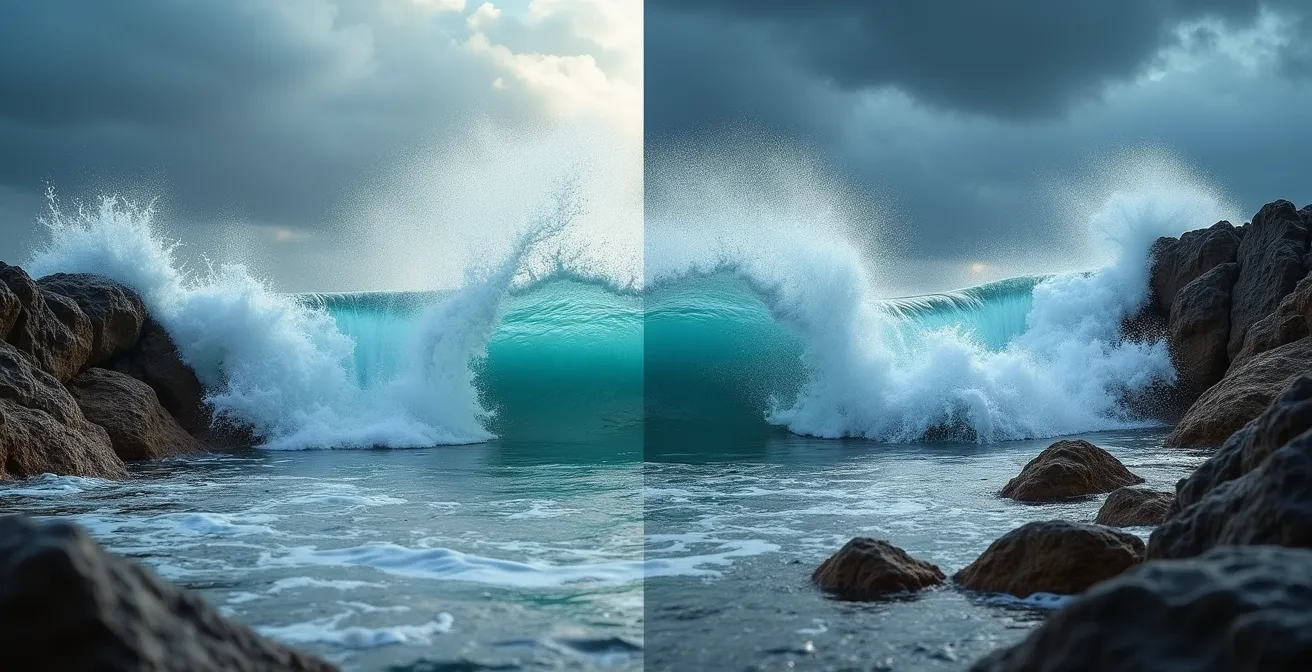
Conversely, a long exposure (1/2s to several seconds), often paired with a neutral density (ND) filter, blurs motion to tell a story of flow and time. It transforms the chaotic sea into a soft, ethereal mist, emphasizing the relentless movement of water over rock. This is perfect for creating a mystical, serene mood, especially around sea stacks like those in British Columbia’s Pacific Rim National Park. More advanced photographers even practice temporal blending, merging a fast-shutter impact with a long-exposure receding flow from the same composition to capture both explosion and movement in a single, hyper-real image.
The following table, based on professional experience in key Canadian and Irish locations, provides a starting point for your creative decisions.
| Location Type | Shutter Speed | Effect | Best For |
|---|---|---|---|
| Giant’s Causeway (Dark Basalt) | 1/1000s+ | Freezes water texture | Sharp impact drama |
| Pacific Rim (Sea Stacks) | 2-4 seconds | Ethereal smoothing | Mystical mood |
| Bay of Fundy (Tidal Bores) | 1/5s – 1/2s | Retains violent texture | Chaotic movement |
| Dingle Peninsula | 1/2s | Mid-range texture | Directional flow |
The Salt Corrosion Mistake That Ruins Lenses in One Season
You’ve captured the shot of a lifetime. The adrenaline is still pumping as you pack your bag and head back to the car, feeling triumphant. This is the most dangerous moment for your gear. The invisible, corrosive salt mist that now coats your camera and lenses is a silent killer. Simply wiping it with a cloth or waiting until you get home is the single biggest mistake a coastal photographer can make. Salt doesn’t just wipe away; it crystallizes, and those micro-crystals will permanently scratch your lens elements and degrade electrical contacts.
Professional practice demands a non-negotiable, three-stage decontamination protocol. This isn’t just “cleaning”; it’s a systematic process to neutralize and remove salt before it can cause irreversible damage. The first stage happens immediately on-site, the second at your vehicle before you drive away, and the third, most thorough stage, occurs back at home or in your hotel room. Skipping any of these steps is a gamble that will, eventually, cost you dearly.
This disciplined approach separates professionals from amateurs. While the amateur worries about a sudden downpour, the professional is more concerned with the insidious, ever-present salt spray. This is also why having specific insurance is critical. Standard policies may not cover gradual corrosion, only sudden immersion. In both Ireland and Canada, specialized photography insurance is available that distinguishes between these two types of damage, a crucial detail for anyone serious about this genre.
Case Study: The Cost of Corrosion – Ireland vs. Canada Repair Services
A professional must also know where to turn when things go wrong. An analysis of repair services shows that the cost and time for salt damage repair vary. For example, Dublin’s Camera Centre Ireland typically offers a 5-7 day turnaround for salt damage repairs costing between €200-€400. In contrast, Vancouver’s Broadway Camera usually requires 10-14 days with costs ranging from CAD $300-$500. Both services recommend specific insurance policies with annual premiums of €300-€500 in Ireland and CAD $400-$600 in Canada to cover this specific type of risk.
Peggy’s Cove vs. Tofino: Which Coast Offers Safer Vantage Points for Storm Watching?
Not all coastlines are created equal when it comes to safety. The geology and infrastructure of a location are as important as the weather forecast. Comparing two iconic Canadian coastal locations, Peggy’s Cove in Nova Scotia and Tofino in British Columbia, highlights the different dangers photographers face on the Atlantic versus the Pacific. While this article focuses on the Atlantic, the comparison provides critical safety lessons.
At Peggy’s Cove, the primary danger is not the wave itself but the slick, dark granite underfoot. Smoothed by millennia of glacial action and constantly wet from spray, these rocks offer treacherous footing. A slip and fall can be just as deadly as being swept away. The tragic history of this location, which includes over 30 recorded fatalities, has led to the installation of new safety barriers, but the fundamental danger of the rock surface remains. Locations like Cape Bonavista in Newfoundland share this exposed, unforgiving rock characteristic.
In contrast, Tofino’s dangers come more directly from the ocean. The Pacific coast is notorious for sneaker waves and massive log debris in the surf. However, the infrastructure within Pacific Rim National Park, including designated viewing platforms and extensive warning signage, provides a more structured and monitored environment. The presence of park rangers adds another layer of safety not typically found at more rugged Atlantic locations. The lesson is clear: you must assess both the natural hazards and the available safety infrastructure of any location. The stark reality of wave danger is universal, as 30 recorded deaths at a single, similar location in Hawaii demonstrate.
This comparative analysis shows that a photographer’s risk assessment must be location-specific.
| Location | Primary Danger | Infrastructure | Safety Record |
|---|---|---|---|
| Peggy’s Cove (NS) | Slick granite causing falls | New barriers post-2021 | 30+ fatalities recorded |
| Tofino (BC) | Sneaker waves & debris | Designated platforms in Pacific Rim NP | Park ranger monitoring |
| Cape Bonavista (NL) | Similar to Peggy’s – exposed rock | Limited safety infrastructure | Apply Peggy’s protocols |
| Long Beach (BC) | Log battering rams in surf | Warning signs extensive | Annual incidents reported |
RAW Processing: How to Bring Out the Detail in White Foam Without Blowing Out Highlights?
Capturing the perfect storm image doesn’t end in the field; it’s often won or lost in post-processing. One of the biggest technical challenges is managing the extreme dynamic range of a storm scene. The bright, chaotic white foam of a breaking wave is incredibly easy to “blow out,” losing all detail and turning into a pure white, textureless blob in your final image. Preserving that intricate, swirling detail is a hallmark of professional work.
The key is to shoot in RAW and use a specific processing technique focused on highlight recovery. Your best tool for this is the Tone Curve in software like Adobe Lightroom or Capture One. Instead of simply pulling down the global “Highlights” or “Whites” sliders, which can flatten the entire image, a targeted curve adjustment gives you surgical control. The goal is to compress the brightest highlights without affecting the mid-tones and shadows, thus preserving overall contrast and punch.

For even greater precision, this technique is combined with luminosity masks. A luminosity mask allows you to apply an adjustment *only* to a specific brightness range—in this case, just the brightest parts of the foam. This lets you aggressively recover highlight detail in the foam without darkening the sky or the surrounding water. The process is meticulous but essential for creating a powerful image where the foam has texture, depth, and form.
The professional workflow for recovering foam detail generally follows these steps:
- Create a custom tone curve in your RAW editor, placing anchor points to lock the mid-tones and shadows in place.
- Aggressively pull down the curve only in the extreme highlight region (the top 5% of the histogram) to recover initial detail.
- Generate a luminosity mask that specifically targets only the brightest foam areas, isolating them from the rest of the image.
- Within that mask, make fine-tuned localized adjustments to clarity, texture, and exposure to further enhance the foam’s structure while preserving the image’s overall contrast.
- Finish with creative color grading, perhaps adding subtle green tints for an Irish coastal feel or cooler blue tones for a Canadian North Atlantic mood.
Why Does the Weather in Newfoundland Change Faster Than in the Rockies?
If you’ve ever photographed in the Canadian Rockies, you know the weather can be unpredictable. But on the coast of Newfoundland, “unpredictable” takes on a new meaning. The speed and extremity of weather changes are on a completely different level. This is not because the forecasting is poor; it’s due to the fundamental difference between continental and maritime weather systems. While mountain weather is driven by elevation and topography, coastal weather is governed by the immense, dynamic forces of the Atlantic Ocean.
The proximity to the Labrador Current (cold) and the Gulf Stream (warm) creates an atmospheric battleground. This convergence means that maritime weather systems in Newfoundland can produce four or five distinct patterns—sun, fog, driving rain, sleet, and back to sun—in the span of a single afternoon. For a photographer, this volatility is both a challenge and an opportunity. It demands a highly adaptable, modular gear strategy where you can react to changing conditions in seconds, not minutes.
This means having a system where every piece of gear serves multiple purposes. A lens hood is not just for sun flare; it’s your first line of defense against rain. A quick-release polarizing filter can be removed instantly when a dark cloud bank rolls in and kills the light. You need multiple sets of lens cloths: a dry one for fog, a damp one for salt spray, and a backup. A simple Ziploc bag and a rubber band can become an instant, effective weather cover. Being prepared for this rapid-fire weather isn’t just about comfort; it’s about being able to continue shooting when the most dramatic light appears.
How to Read Glacial Ice Calving Signs Before It’s Too Late?
While stormy ocean swells are a primary draw, the Atlantic coasts of Newfoundland and B.C. offer another powerful, and equally dangerous, spectacle: glacial ice calving. Photographing a massive chunk of ice shearing off a glacier and crashing into a fjord is a breathtaking experience. However, the wave generated by this event can be catastrophic if you are too close. Reading the signs of an imminent calving event is a critical survival skill, parallel to reading ocean wave sets.
Experienced photographers in these glacial lagoons listen as much as they look. The first sign is often auditory: a deep, groaning or cracking sound from within the ice, indicating internal stress and movement. Visually, you should watch for new or rapidly widening crevasses on the glacier’s face and for smaller pieces of ice starting to fall. These are the precursors to a major calving event. The biggest mistake is to be lured in by the beauty and get too close for a wider shot.
Professional safety protocols in these environments are based on strict distance-to-height ratios. For a glacier with a 30-meter (approx. 100-foot) face, the minimum safe distance is 150 meters (approx. 500 feet). This is not a recommendation; it’s a hard-and-fast rule, as major events can generate 20-25 ft displacement waves that can easily swamp a boat or a low-lying shoreline. This necessitates the use of a substantial telephoto lens (400mm or more) to safely compose a powerful shot. Approaching any closer is a life-threatening gamble.
Key Takeaways
- Safety Through Prediction: The best photographers don’t react to danger; they predict it by studying marine charts and coastal topography to find safe, strategic vantage points.
- Creative Control Over Motion: Mastery lies in deliberately choosing your shutter speed to either freeze the violent detail of a wave or blur its movement into an ethereal flow.
- Gear Longevity Is a Process: Your equipment’s survival depends not on a rain cover, but on a disciplined, multi-stage decontamination protocol to combat corrosive salt spray.
Exploring Newfoundland’s Rugged Coast: The 5 Safety Rules for Solo Hikers
The title of this section mentions “solo hikers,” but for a storm photographer on the Newfoundland coast, the rules must be modified and amplified. Shooting alone during a building storm is a violation of the most fundamental safety principle. The professional approach synthesizes standard hiking safety with the unique, dynamic risks of coastal storm photography. These rules are not guidelines; they are your lifeline when facing the raw power of the Atlantic.
The consequences of ignoring these protocols are severe and well-documented. Analysis of recent incidents at popular but dangerous Newfoundland headlands consistently shows that photographers who were swept away had violated the 50-foot minimum distance rule during high-energy storm swells. They positioned themselves too close to the last high-water mark, believing their telephoto lens was not long enough or that they could react in time. A rogue wave, by its nature, leaves no time for reaction. Your safety is determined by the decisions you make *before* the wave ever appears.
Here are the five essential rules, modified for the storm photographer:
- Rule 1: Trust Marine Data, Not Just Weather Apps. Your primary check before heading out must be the wave period, swell height, and tide times. A sunny forecast is irrelevant if a long-period, high-energy swell is hitting the coast.
- Rule 2: Know When to Abandon Your Tripod. A tripod is an essential tool, but it can also be a liability. It anchors you to a spot and can be slow to move. If conditions change rapidly, you must be mentally prepared to abandon it without hesitation. Your life is worth more than your gear.
- Rule 3: Carry a Satellite Messenger. Much of Newfoundland’s most dramatic coastline has no reliable cell service. A device like a Garmin inReach or Zoleo is not a luxury; it’s essential safety equipment for communicating in an emergency.
- Rule 4: The 50-Foot Rule Is Absolute. Maintain a strict minimum distance of 50 feet (15 meters) from the last visible high-water mark. Never let the perceived need for a “better” composition tempt you into this zone.
- Rule 5: Never Shoot a Building Storm Alone. Always have a spotter whose only job is to watch the sea while you are looking through the viewfinder. Their undivided attention can provide the critical seconds of warning you need.
Adopt these protocols not as constraints, but as the professional framework that enables creative freedom. By managing risk proactively, you free yourself to focus on what matters most: capturing the profound and wild beauty of the stormy sea. Begin integrating these safety and maintenance procedures into your workflow now, before your next coastal expedition.