Hiking in Newfoundland is not a mountain challenge; it is a maritime survival exercise where moisture, not altitude, is the primary threat.
- The constant collision of the Labrador Current and Gulf Stream creates a uniquely hostile environment of persistent fog, damp, and rapid weather shifts that standard gear and mountain-based assumptions cannot handle.
- Success depends on mastering moisture management (wool over Gore-Tex), anticipating navigational failure due to cold-induced battery drain, and respecting the fragile, unforgiving coastal topography.
Recommendation: Abandon the “conquer the summit” mindset. Adopt a “respect the ocean” approach, prioritizing minimalist packing, weather-window discipline, and absolute gear redundancy.
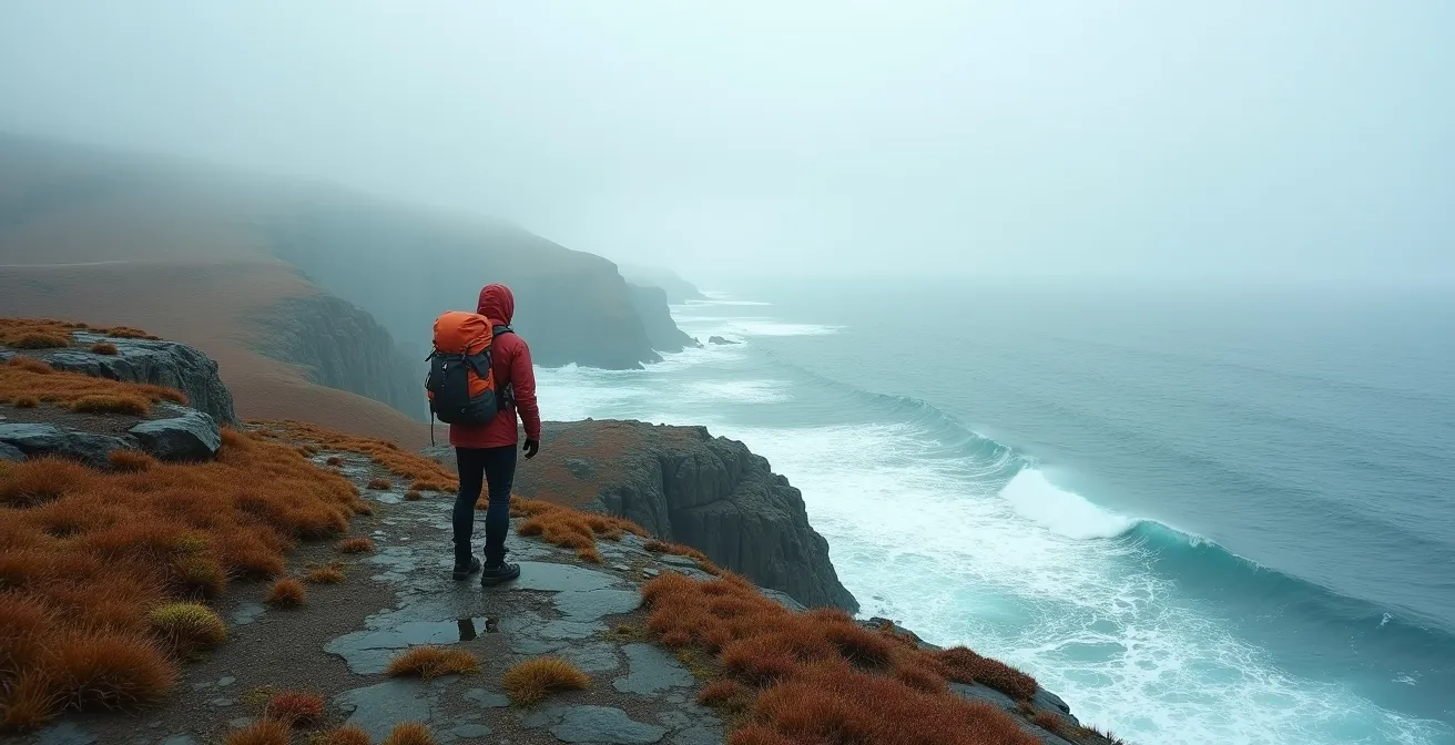
The call of Newfoundland’s coast is primal. It’s a landscape of dramatic cliffs, fjord-like bays, and a raw, untamed beauty that pulls in adventurers from around the globe. You’ve likely seen the photos: icebergs calving in the distance, puffins nesting on sea stacks, and trails winding over emerald-green headlands. If you are an experienced hiker, perhaps with years of trekking through the Rockies or the hills of the UK under your belt, you might feel prepared. You know how to layer, how to read a map, and how to push through a tough day.
This is a dangerous assumption. The standard advice—pack rain gear, tell someone your plan, check the forecast—is dangerously inadequate here. These are mountain rules for a maritime problem. The fundamental mistake hikers make in Newfoundland is underestimating the influence of the North Atlantic. The ocean is not just a backdrop; it is the engine of a weather system so volatile and an environment so saturated with moisture that it requires a complete shift in your survival mindset.
The truth is, your Gore-Tex shell will fail you. Your GPS battery will die faster than you expect. And the fog will do more than just obscure the view; it will erase the world. This is not about gaining altitude; it’s about surviving a constant battle against cold and damp. This guide is not a list of pleasant tips. It is a direct, authoritative breakdown of the unique hazards of the Newfoundland coast and the specific strategies required to navigate them safely. We will dissect the science behind its treacherous weather, evaluate the gear that actually works, and expose the critical mistakes that leave even seasoned hikers stranded. Forget what you think you know about hiking. Here, the ocean makes the rules.
This article will provide a rigorous examination of the specific environmental challenges and the tactical preparations necessary for a safe solo expedition along Newfoundland’s coast. The following sections break down everything from atmospheric science to practical gear choices.
Summary: Master Newfoundland’s Coast: A Survival Guide for Solo Hikers
- Why Does the Weather in Newfoundland Change Faster Than in the Rockies?
- Gore-Tex vs. Traditional Wool: Which Layering System Wins for North Atlantic Hiking?
- Leave No Trace: How to Camp on Coastal Moss Without Destroying the Ecosystem?
- The GPS Mistake That Strands 50 Hikers a Year on the East Coast Trail
- June vs. September: When Is the Best Time to Avoid Black Flies and Fog?
- Sea Level to Summit: How Fast Is Too Fast for Your Body to Adapt?
- The “Just in Case” Mistake: What Not to Pack for a Minimalist Forest Retreat
- How to Train for a Winter Ascent in the Chic-Chocs Mountains?
Why Does the Weather in Newfoundland Change Faster Than in the Rockies?
To understand Newfoundland’s weather, you must first understand it is not a mountain climate; it is a battleground of oceanic forces. The primary reason for its extreme volatility is the direct collision of two massive ocean currents just offshore: the icy Labrador Current flowing south from Greenland and the warm Gulf Stream pushing north from the tropics. As an analysis of the region’s climate explains, this clash gives rise to frequent rainfall, relentless wind, and pervasive mists. This isn’t a seasonal phenomenon; it’s a constant atmospheric war.
The “sea smoke” or fog, is particularly hazardous. It develops when warm, humid air strikes the cold waters of the Labrador Current. This can happen in any season, creating a dense, disorienting blanket that reduces visibility to near zero in minutes. The statistics are stark: St. John’s holds the Canadian record with 124 days of fog per year. This is not the gentle morning mist of an alpine valley; this is a navigational whiteout where sea and sky merge into one.
A continental climate like the Rockies has more predictable patterns. A maritime climate like Newfoundland’s is defined by its instability. The following comparison illustrates the fundamental difference in environment you must prepare for.
| Weather Factor | Newfoundland | Rocky Mountains |
|---|---|---|
| Annual Sunshine Hours | <1600 hours | 2314 hours (Calgary) |
| Climate Type | Maritime (highly variable) | Continental (more stable) |
| Fog Days | 124 days/year | Minimal |
| Storm Frequency | Most frequent Nov-March | More predictable patterns |
| Wind Speed Average | 24.3 km/h | Less windy overall |
Do not trust the forecast. A sunny start means nothing. You must operate with the assumption that severe weather is not a possibility, but an inevitability. Your preparation must reflect the reality of this maritime system, not the expectations of a mountain hike.
Gore-Tex vs. Traditional Wool: Which Layering System Wins for North Atlantic Hiking?
In most hiking environments, a high-quality Gore-Tex shell is the gold standard for staying dry. In Newfoundland, it is a liability if relied upon exclusively. The concept you must master is not “waterproofing” but moisture saturation management. The air itself is often heavy with dampness from fog and sea spray, and the trails are notoriously boggy. The St. Lawrence area, for example, can receive over 1,500 mm (59 inches) of precipitation annually. This creates a state of perpetual dampness that no breathable membrane can fully overcome.
Gore-Tex and similar fabrics work on a pressure and temperature gradient. They are designed to expel water vapor when it’s warmer and more humid inside your jacket than outside. In the cool, saturated air of a Newfoundland fog bank, this gradient diminishes or even reverses. Your sweat condenses on the inside, and the external fabric “wets out,” becoming a cold, clammy barrier. The promise of “waterproof-breathable” fails.
This is where traditional wool demonstrates its superiority. Wool is hygroscopic, meaning it can absorb up to 30% of its weight in water without feeling wet to the touch. Crucially, it retains its insulating properties even when damp. A wool base layer will continue to keep you warm, while a wetted-out synthetic layer will actively pull heat from your body. Your layering system must be built on a foundation of wool or high-quality wool blends for all next-to-skin layers. Your waterproof shell is your last line of defense against driving rain, not your solution for the pervasive damp. Assume your feet will be wet; plan for it with wool socks and footwear that drains rather than holds water.
Leave No Trace: How to Camp on Coastal Moss Without Destroying the Ecosystem?
The answer is simple: you don’t. The lush, green carpets of moss and heath that cover Newfoundland’s headlands are exceptionally beautiful and catastrophically fragile. This is not a durable alpine meadow. These are slow-growing, delicate ecosystems that can take decades to recover from a single misplaced footstep, let alone the impact of a tent.
The photograph below shows the intricate, delicate structure of this coastal vegetation. It is a living skin over the rock, holding thin soil and moisture. Compressing it with a tent not only damages the plants but also disrupts the fragile hydrological balance of the headland.

The only responsible way to camp is to use designated platforms or durable surfaces. The East Coast Trail Association mandates the use of its designated, free-to-use campgrounds. These are specifically sited to minimize impact. If you are an experienced hiker caught in an emergency and must make camp outside of these sites, the rule is to choose rock, not cushion. Find exposed bedrock, a gravel beach, or a durable patch of dirt. Never, under any circumstances, pitch a tent on the coastal heath or moss.
This principle extends to all aspects of your presence. Open fires are strictly forbidden; a camp stove is mandatory. Everything you pack in, you must pack out. There are no garbage facilities on the trail. Your goal is to move through this landscape as a ghost, leaving no evidence of your passing.
Action Plan: Emergency Camping on the Coast
- Prioritize designated campsites: Always plan your route around the official, free-to-use campgrounds provided.
- Assess durable surfaces: If an emergency forces an unplanned stop, scan for exposed bedrock, gravel, or dry sand. These are your only options.
- Confront the ecosystem: Explicitly identify fragile vegetation like moss, lichen, and heath. These are absolute no-go zones.
- Evaluate your impact: Before setting up, ask: “Will my presence here leave a mark that lasts more than a day?” If the answer is yes, move.
- Commit to Zero Trace: Plan to pack out every single item, including food scraps. Leave the site visibly untouched.
The GPS Mistake That Strands 50 Hikers a Year on the East Coast Trail
On a trail system that sees over 14,000 visitors completing over 65,000 hikes annually, navigation errors are inevitable. However, the most critical mistake on the Newfoundland coast isn’t misreading a map; it’s over-reliance on a single electronic device. Your smartphone or GPS unit is not infallible, and this environment is uniquely suited to cause its failure at the worst possible moment.
The primary culprit is not a loss of signal, but catastrophic battery drain. The cold, humid conditions of the coast are poison to lithium-ion batteries. Real-world experience shows that the persistent damp and cool temperatures can drain batteries up to 50% faster than normal. A hiker starting the day with a full charge can find their device dead by midday, especially if they are also using it to take photos. When the fog rolls in and visibility drops to a few feet, the loss of your primary navigation tool becomes a life-threatening emergency.
Relying solely on a GPS is a rookie mistake with professional-level consequences. As experienced hiker Bonnie Thornbury states in her guide on trail safety, an SOS device is non-negotiable. She emphasizes, “An SOS device is a must, regardless of whether you’re hiking solo or with a group… The SPOT or Garmin inReach devices are both good options.” These devices are not just for emergencies; their robust build and superior battery performance in harsh conditions make them a more reliable primary navigation tool.
Your navigation strategy must be redundant. It should include:
- A fully charged, dedicated GPS device or satellite messenger, kept warm in an internal pocket.
- A backup power bank, also kept warm and dry.
- Physical maps of the trail system in a waterproof case.
- A quality compass and the knowledge to use it with the maps.
The mistake is not using a GPS. The mistake is trusting it will work when you need it most.
June vs. September: When Is the Best Time to Avoid Black Flies and Fog?
Choosing the right time to hike in Newfoundland is a strategic trade-off. There is no single “perfect” month, only a choice between different sets of challenges and rewards. The two most popular hiking seasons, June and September, offer dramatically different experiences. Your decision must be informed by a clear understanding of what you are willing to endure.
June is the season of icebergs and whales. It is a time of incredible spectacle, but it is also the peak season for two of the coast’s greatest miseries: black flies and fog. The biting insects can be relentless, turning a scenic rest stop into a torturous ordeal. Furthermore, the temperature contrast between the cold ocean and warming land is at its greatest, leading to the highest frequency of dense fog. Some trails may also be closed for ecological reasons or due to lingering snow and mud.
September, by contrast, is a season of clarity and harvest. The black flies are gone, and the fog is significantly less frequent, offering more days with clear, crisp air. The trails are firm and dry, and the coastal heath is laden with wild blueberries and partridgeberries. While the icebergs have long since departed, the trade-off is a more stable, comfortable, and predictable hiking experience. The fall colors create a different, but no less stunning, kind of beauty.

The following table provides a direct comparison to guide your decision. There is no right answer, only the answer that aligns with your priorities and tolerance for environmental hazards.
| Factor | June | September |
|---|---|---|
| Icebergs | Prime viewing season | None |
| Black Flies | Peak season | Minimal |
| Fog Frequency | Highest (spring/early summer) | Reduced |
| Trail Conditions | Some trails closed (ecological reasons) | All trails open |
| Special Features | Capelin roll phenomenon | Wild berries abundant |
| Temperature | Cool, variable | Mild, more stable |
Sea Level to Summit: How Fast Is Too Fast for Your Body to Adapt?
The climbs along the Newfoundland coast are not high in absolute altitude. You will not be dealing with altitude sickness. This leads many hikers to underestimate the physiological challenge. The danger here is not a lack of oxygen, but the high metabolic cost of rapid, repeated elevation changes in a cold, wet environment. Sections of the East Coast Trail feature trails that range from 239 to 3,602 feet of elevation gain, often in a sawtooth pattern of steep descents to sea level followed by grueling ascents back to the clifftops.
Each climb forces your body to generate significant heat. In a dry climate, this is managed by sweating. Here, you are already damp from the environment. Pushing too hard on an ascent will soak your base layers from the inside, and the moment you stop, the cold, windy conditions on the exposed headland will begin to pull that heat away with dangerous speed. This is how exhaustion and hypothermia take hold, even on a day that doesn’t feel particularly cold. Your body is simply burning through its energy reserves to stay warm.
The correct pacing strategy is counter-intuitive for fit hikers: go slow. You must manage your effort to minimize sweating. Monitor your heart rate and keep it in a sustainable aerobic zone (below 70% of max HR) on the climbs. This is not a race to the summit. It is a calculated effort to conserve energy over a long day. Proper adaptation is about pacing and hydration—Parks Canada recommends taking at least 3 litres of water per person, and up to 5 on hot days—to manage the sustained effort, not about acclimatizing to altitude.
The “Just in Case” Mistake: What Not to Pack for a Minimalist Forest Retreat
The title of this section might seem out of place, but its principle is vital for the coast: overpacking is a critical safety mistake. The impulse to carry gear “just in case” is understandable, but on the rugged, undulating terrain of the Newfoundland coast, every extra pound carries a heavy penalty. It increases fatigue, slows you down, and dramatically heightens the risk of slips, falls, and joint injuries. More importantly, it directly correlates with the breakdown of your most critical piece of gear: your feet.
A real-world account from a group fastpacking the East Coast Trail provides a stark illustration. Three hikers carried packs weighing 28 lbs, 22 lbs, and 15 lbs. The hiker with the heaviest pack (carrying extra camera gear) had the most severe foot problems, while the hiker with the lightest pack finished in the best condition. The conclusion was unavoidable: pack weight is a direct predictor of foot health. In an environment where your feet are almost constantly wet, minimizing weight and friction is paramount to preventing the blisters and tissue damage that can end a trip.
Minimalism here is not a trend; it is a survival strategy. You must ruthlessly audit your gear. Do you need a heavy tent, or can you manage with a lightweight tarp? Do you need a comprehensive medical kit, or can you rely on a micro-kit for immediate issues and a satellite beacon for true emergencies? Focus on multi-use items and quick-drying materials. The goal is to build a system that is light, efficient, and resilient to moisture. Do not pack for your fears. Pack for the reality of the trail.
Key Takeaways
- Newfoundland’s weather is a maritime system, not a mountain one. Prepare for constant moisture and fog, not altitude.
- Choose wool layers over synthetics for their superior insulation when wet. Your “waterproof” gear will not keep you dry alone.
- Never camp on fragile moss or heath. Stick to designated sites or durable rock surfaces to prevent decades of ecological damage.
- Electronics will fail. Carry redundant navigation tools, including physical maps, a compass, and a satellite messenger, and protect batteries from the cold.
How to Train for a Winter Ascent in the Chic-Chocs Mountains?
This question seems to belong to a different expedition entirely, and that is precisely the point. The training, skills, and mindset required for a classic Canadian winter ascent in Quebec’s Chic-Chocs—involving deep snow, avalanche safety, and extreme cold—are fundamentally different from what is required to survive a solo hike on the Newfoundland coast. Preparing for the wrong challenge is a recipe for disaster. Many experienced hikers make this exact mistake.
As the Quebec Avalanche Center warns, experience in cold, wet, and windy conditions does not automatically translate to readiness for all challenging environments. In a blunt assessment aimed at those with similar backgrounds, they state, “Your Irish Hillwalking Skills are Not Enough.” This is not an insult; it is a critical safety warning. The skills to navigate boggy, windswept hills in Ireland or Scotland are a valuable foundation, but they do not prepare you for the unique combination of navigational whiteouts from sea fog, the physiological drain of constant moisture saturation, and the specific topographical traps of the Newfoundland coast.
The training focus must shift. Instead of training for cardiovascular power in deep snow, you need to train for endurance and joint stability on relentlessly undulating, slippery terrain. Instead of avalanche rescue skills, you need to master redundant navigation and battery management. The table below highlights this critical distinction. Are you training for the right fight?
| Training Focus | East Coast Trail | Chic-Chocs Winter |
|---|---|---|
| Primary Fitness Need | Endurance for undulating terrain | Cardiovascular power for deep snow |
| Key Muscle Groups | Joint stability, eccentric control | Core strength for pack weight |
| Technical Skills | Wet weather navigation | Avalanche training (AST 1) |
| Equipment Training | Hiking poles, wet-weather gear | Snowshoes, crampons essential |
| Environmental Prep | Fog/rain/wind management | Extreme cold survival skills |
Success on the Newfoundland coast requires humility. You must be willing to unlearn certain mountain-based assumptions and adopt a new set of rules dictated by the ocean. It demands respect not for the height of the peaks, but for the power of the sea.
Re-evaluate your entire preparation through this maritime lens. Your safety depends not on the skills you already have, but on your ability to adapt to a challenge for which you are not yet prepared. Begin your training now.